
Why did you choose to become a surveyor?
My time as a child was spent being outside and playing sports. Academically, I enjoyed mathematics. A newspaper article by a surveying leader, the late Brenton Burford, suggested I could have a career by combining those interests. My mind was made up and I never looked back.
How has the profession changed since you graduated?
The 1980s saw the transition from manual ‘chaining’ to the use of electronic distance measuring devices (EDM). Many surveyors were sceptical of the new technology and continued to use the “old” methods. The presentation of surveying information was predominantly through hand-drawn survey plans. Government departments were the biggest users of computing capacity in the surveying world. These were mainframe computers and applications, and the development of surveying/engineering packages was in its infancy.
Progression into global positioning systems (GPS) was beginning and the personal computer was starting to have an impact.
Now, much of our work relies on devices that capture, store, compute and present digital survey information. Mobile computing, the internet of things, and the ever-present positioning capability have combined to change the landscape of the world of measurement and data capture.
Through all this, there is one constant: the skilled professional, in my case, the licensed surveyor.
Professionals are still required to provide appropriate advice for making decisions about the quality, suitability, and application of the data captured. Even in a world of machine learning and artificial intelligence, those skilled professionals are needed to “educate” the machines. The machines can analyse and present data faster than a human operator, but they cannot make informed and quality decisions. This remains the role of the licensed surveyor in land administration.
A career in surveying allows you to choose your own adventure. Gaining skills in areas such as cloud computing, machine learning, artificial intelligence, and computer coding, in addition to skills in surveying, will help create a bright future.

Craig Sandy, Surveyor-General of Victoria
What’s driving the demand for surveyors? What are the big drivers?
The big drivers are population growth, migration towards urban environments, the need to house people, the need for people to have meaningful work, and to move people around our growing cities. Outcomes are projects such as large housing developments, high-rise buildings, underground railway systems, road and rail upgrades, state parks, and reserves converting to Traditional Owner management.
The move toward a fully digital economy is a different type of driver. The need for efficiency, transparency, and delivering services in real-time are consumer drivers that all governments and businesses are facing. It is also driving the program of reform in the surveying profession.
What advice would you give someone thinking of studying to be a surveyor?
A career in surveying is exciting and rewarding. Making good choices about your development path will provide knowledge and skills for your future. A career in surveying allows you to choose your own adventure. Gaining skills in areas such as cloud computing, machine learning, artificial intelligence, and computer coding in addition to skills in surveying will help create a bright future.
A focus on technical skills is an important and fundamental part of a professional’s development. Equally important is the development of communication and leadership skills. Everything we do is focused on people; working with others and understanding their needs, is key to our future.
What does the profession offer women?
For all surveyors, men and women, the attraction of working outside sometimes, and in the office at other times, is a constant. Practicing as a licensed surveyor requires an understanding of the law related to land. This does not require working outdoors. Some of the best-licensed surveyors supervise their staff from the comfort of their favourite chair. The possibilities are endless and open to the imagination of the individual.
Flexibility is no longer nice to have; it is now a must for all employers that wish to attract and retain the best talent.
Tell us more about the role and work of The Surveyor-General of Victoria.
The Surveyor-General of Victoria is a branch within Land Use Victoria and consists of 5 operational teams, Geodesy, Cadastral Infrastructure and Standards, Crown Survey Approval, Geographic Names, and the secretariat for the Surveyors Registration Board of Victoria. Our branch includes five graduates receiving training towards their registration as licensed surveyors. Current projects include:
- Upgrading the GPSnet network with multi-Global Navigation Satellite System (GNSS) receivers, new routers, and telecommunications systems.
- Working on the Australian Vertical Working Surface, a future replacement of the Australian Height Datum.
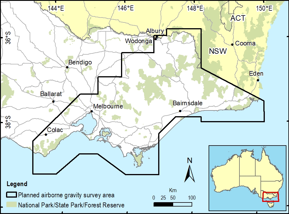
- The Airborne Gravity Survey of Victoria with partners. Geoscience Australia and Geological Survey Victoria is an essential element of this work.
- The Digital Cadastre Modernisation project is capturing approximately 3.3 million land parcels in Victoria. The parcel data will be compiled, adjusted, and integrated with other spatial data sets to improve spatial accuracy.
- Delivering our new SGV Connect 2.0 application to improve the digital flow of land and survey data between our clients and our teams.
- Working with our NSW colleagues to deliver an updated spatial representation of the NSW-Victorian border, the culmination of a decade of effort. This work will be used to inform agencies of the border for activities like recent restrictions and grants across border zones.
- Preparing for the United Nations Decade of Indigenous Language. Working with Traditional Owners, we are helping ensure more Aboriginal language is used for place names throughout Victoria.
- The Surveyors Registration Board of Victoria is reviewing its licensing process. The aim is to ensure the quality of licensed surveys is maintained while removing any roadblocks. The board is also working on an education piece for the broader land development industry about cadastral surveys, which will include fact sheets, conference presentations, templates, and more to educate the sector about the use of a cadastral survey, the people qualified to perform these surveys and the level of quality expected.
- Supporting the new Great Ocean Road Coast and Park Authority to take ownership and manage the land around this iconic road stretching 243 kilometers. This included our Coordinated Imagery Programs team delivering airborne and mobile scanned data and high-resolution aerial photography of the entire road. It was the biggest project of its kind in Victoria.
In addition, the Surveyor-General of Victoria supports all the Big Build projects to ensure that Crown boundaries are accurate and new land parcels are defined and ready for transactions. This includes Metro Tunnel, West Gate Tunnel, Northeast Link, Level Crossing Removal Project, and Suburban Rail Loop.
Fast forward to 2050. How will technology have transformed the work of Victoria’s surveyors?
Digital Twin Victoria will change the way we plan, manage and monitor land within our state. Surveyors will contribute to the ecosystem of digital data required to ensure our state’s land administration systems operate efficiently and effectively.
Surveyors are needed to ensure the digital data can be translated into the actual. This applies to buildings, air space, and natural features.
We will continue to ensure people have a place to live, to work, to be educated, and ways to move around. While people inhabit Victoria, surveyors will be needed to ensure that we understand and manage the use of land.
For more information on Victoria surveying work, please visit the website – land.vic.gov.au/surveying
Note: Craig Sandy spoke to The Chalk as a representative of the Victorian surveying profession and does not endorse any individual companies or products. His comments represent his views alone – not indicative of broader Victorian Government policy.